

Man’s fascination with space exploration comes from a deep-seated desire to understand our universe. Satellite launches and manned missions have got us excited, and our obsession with understanding space around us only seems to grow year by year. As modern science techniques evolve and expand, so do remote sensing capabilities. As a result of this, we can investigate space and bring back stunning Earth images from one of the many thousand satellites that are now orbiting it. Ever since the first satellite image was captured in 1947, we have been launching satellites via rockets and placing cameras on them for many years since. Those images are very complex and stunning, so let’s look at some of the best pictures from space. You might be wondering what satellite cameras look like, but the real question is what kind of images can they produce. Let’s take a look at the best.
Hurricane Edouard
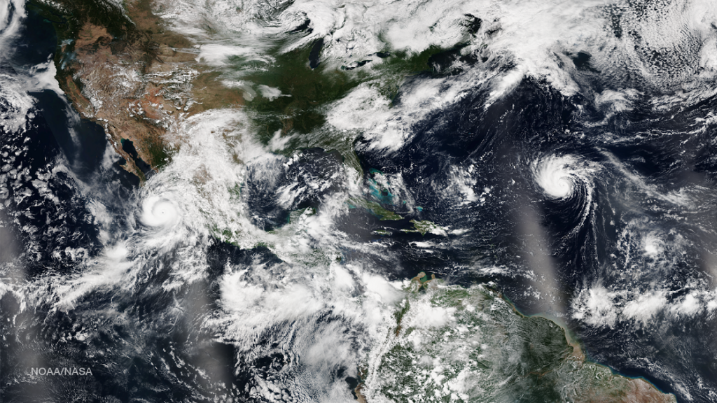

Many people remember the image of 2014’s Hurricane Edouard, taken by NASA during their 41st trip to the International Space Station. The hurricane, which began as a tropical storm, grew in intensity into a major disaster that created a series of dangerous swells and ocean currents along the East Coast. Fortunately, the hurricane never touched land itself, but it left some remarkable images in the oceans it passed through. This particular image shows just how to use the satellite camera to capture the majesty of natural disasters.
The Sea of Marmara’s Plankton Bloom
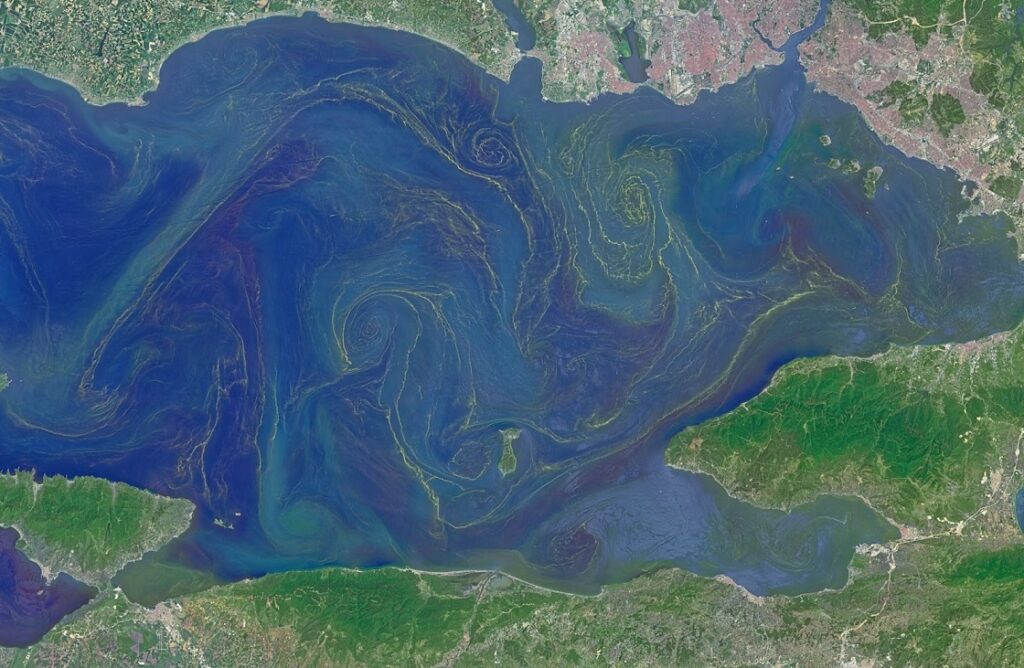

Situated in the middle between the Aegean and Black seas, this glacier has an unusual makeup. On the surface is fresh water and deep below sits salty water. As a result of this environment, phytoplankton grows all over the surface, creating a breathtaking swirling pattern when viewed from a satellite camera several thousands of meters above. Do take a look at the iconic and famous image taken from NASA’s Operational Land Manager in 2015 to see how majestically this phytoplankton flows and illuminates.
Middle Eastern, African and European Lights
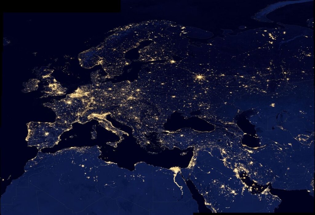

Who could forget this iconic earth observation image? An outstanding and breathtaking composite image of views of the Middle East, Africa, and Europe. The image was made using data from a satellite known as Suomi NPP, mapped over existing images of our Earth. The cameras onboard the satellite have infrared imaging technology that allows it to detect light, filtering out any light from other sources. The result is an image that only focuses on city lights, and it’s phenomenal to see.
The Yakutat Glacier

This stunning image of Alaska’s mass of ice and snow was taken with a satellite camera in space on NASA’s Operational Land Imager. It’s a poignant image, particularly as it shows just how much our current climate crisis has caused it to decrease in size. Unfortunately, scientists using satellite cameras to monitor this area of the earth are predicting that the glacier could be completely gone by 2070 if global warming continues at the pace it’s moving.
Mount Brandberg


Another image from NASA shows just how regal the peak looks as it stands out up against the desert landscape. Taken in 1993, this image showcases the highest mountain in Namibia, standing at over 8000 feet and created millions of years ago from volcanic activity. You can see it on earth from great distances across sections of the Namib Desert, but this particular image is arguably the most pretty view. It’s known as the burning mountain because it can sometimes appear to glow bright red when the sunsets.
Bangladesh River Flooding
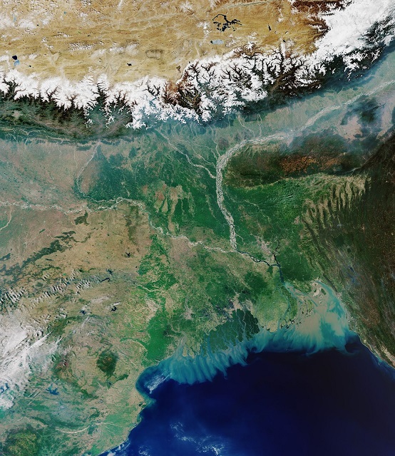

Satellites captured an iconic image of Bangladesh, showing the flooding of one of its most famous rivers, the Padma River. Erosion caused the river to diverge and change flow at an alarming rate before collapsing and causing widespread damage. Scientists tracked the area for years, taking photos in an attempt to analyze and determine a pattern of change in the river.
Stunning Pictures from Earth Observation
These images are beautiful and inspirational – you might be thinking about how a satellite camera works to capture such incredible images? It’s beyond the scope of this article, but what we do know is that a vast number of incredible images have been produced, and these images here are just the tip of the iceberg! There are many more images just like these to marvel at. As technology gets better, our remote sensing capabilities will likely capture even more breathtaking images.